Wildfires and Latino Communities: Health, Economic, and Preparedness Challenges
Introduction
Over the past few days, wildfires have swept through various communities in Los Angeles County. While the public focus has centered on the impact on more affluent foothill neighborhoods, the unique vulnerabilities of other communities, including Latino neighborhoods, remain largely overlooked. These communities face intersecting vulnerabilities, including higher exposure to air pollution, preexisting health conditions, employment in outdoor industries, and systemic barriers such as limited health insurance coverage amongst the population and gaps in emergency preparedness for small businesses. Together, these factors amplify the health, economic, and recovery challenges Latinos experience during wildfire events. This data brief highlights these compounded threats during the ongoing Palisades, Hurst, and Eaton fires, underscoring the urgent need for equitable disaster response and recovery efforts tailored to the needs of Latino and other marginalized communities.
Data Source and Methodology
This data brief draws on multiple data sources to analyze the impacts of current wildfires and to examine the characteristics of Latino neighborhoods that make residents particularly vulnerable:
- Demographic data on race and ethnicity were obtained from the 2020 Decennial Census.
- Socioeconomic data, occupation, and health insurance coverage were derived from the 2018–2022 5-year American Community Survey (ACS).
- Pollution and health data, including diesel particulate matter (PM) exposure and asthma-related ER visit rates, were sourced from CalEnviroScreen 4.0.
Impacted communities are defined as those located within mandatory evacuation zones and evacuation warning zones as outlined by CalFire on January 8, 2025 at 2 p.m. PST. According to CalFire:
- Evacuation Order Zones face an immediate threat to life. Residents are legally required to leave immediately, and the area is closed to public access.
- Evacuation Warning Zones are areas facing a potential threat to life and/or property. Individuals requiring additional time to evacuate, as well as those with pets and livestock, are advised to leave immediately.
To estimate the number and proportion of different racial/ethnic groups in these evacuation zones, we used 2020 Decennial Census Block data and intersected it with the evacuation zones using GIS. Areal weighting was applied, considering the proportion of each census block that falls within the evacuation zones, to calculate population estimates.
Latino and non-Latino White (white) neighborhoods are defined as census tracts where Latinos or whites represent at least 70% of the population, respectively. The statistics presented, including metrics such as exposure to diesel PM and PM2.5, asthma-related ER visits, proportions of outdoor workers, and rates of uninsured individuals, represent average rates at the neighborhood level rather than the population level. The data were tabulated before the Lidia Fire and Sunset fires. It is important to note that these estimates are subject to change as wildfire conditions evolve and new information becomes available. Further, the zones used in the analysis are larger than the fire perimeters of the general burn areas.
Findings
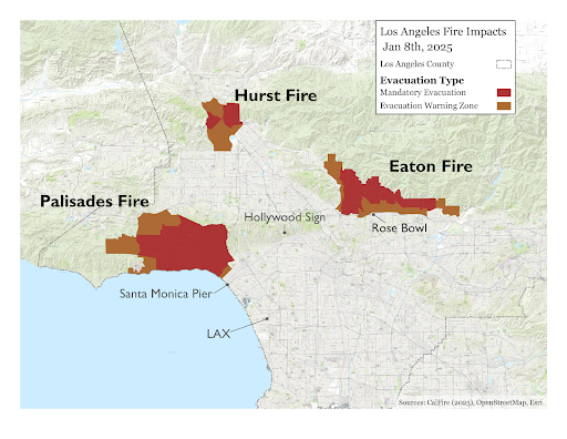
Map 1 displays evacuation and warning zones for three wildfire sites: the Palisades Fire, the Eaton Fire, and the Hurst Fire, along with the communities they impact. The Palisades Fire, originating in Pacific Palisades, has spread to Malibu and Calabasas, prompting widespread evacuations. The Eaton Fire, located in Eaton Canyon near Pasadena and Altadena, has caused significant structural damage and fatalities. The Hurst Fire, burning in Sylmar, threatens nearby communities in the San Fernando Valley. This map highlights the widespread impact of wildfires on various Los Angeles neighborhoods.
Map 1. Evacuation Order & Warning Zones for Eaton, Palisades, and Hurst Fires
Source: CalFire, available online.
Finding 1: At least 74,000 Latinos were at risk of direct displacement or were displaced due to the wildfires.
Figure 1 below illustrates the estimated number of individuals at risk of displacement or displaced by recent wildfires in Los Angeles County under evacuation orders or warning zones. As of January 8, 2025, at 2 p.m., we estimate that at least 323,000 Angelenos have been affected. Among them, at least 74,000 were Latinos, representing about 1 in 4 of those impacted.
The populations impacted by the wildfires show notable demographic variation. While white residents form the majority across all three fires (52% overall), affected communities are distinct. For the Hurst Fire in Sylmar, Latinos constitute a significant portion (33%) of the affected population, reflecting the area’s demographic makeup. The Eaton Fire impacts a more diverse group, with Latinos making up 27% and Asians 18%, alongside a predominance of white residents (43%). In contrast, the Palisades Fire area has the highest proportion of white residents (79%), with minimal Latino (7%) and Asian (7%) representation. The demographic disparities in evacuation zones mirror deeper systemic inequities in environmental health and access to resources, as explored in the next section.
Figure 1. Estimated Population Impacted by Eaton, Palisades, and Hurst Fires
Note: Latinos include those who identify as Hispanic or Latino of any race; white, Black, and Asian categories exclude those who identify as Hispanic or Latino.
Source: Tabulated by authors from the 2020 Decennial Census.
Finding 2: Preexisting Health and Pollution Inequities Amplify the Health Impacts of Wildfires on Latino Residents in Los Angeles
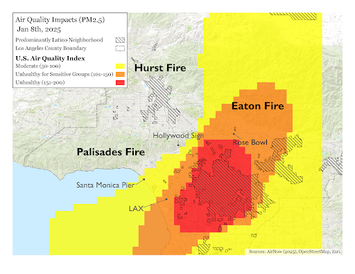
Map 2 shows the location of Latino neighborhoods in Los Angeles County in relation to the U.S. Air Quality Index on January 8, 2025, at 2 p.m. While Latino neighborhoods may be less likely to fall within areas directly impacted by fire zones (see Map 1), the health effects of wildfires disproportionately affect Latino communities due to their heightened exposure to preexisting pollution burdens, which wildfires only worsen.
Map 2. U.S. Air Quality Index and Location of Latino Neighborhoods in Los Angeles
Source: AirNow.gov, API Developer Tools, available online.
Residents in Latino neighborhoods already face disproportionately high levels of pollution, including exposure to diesel particulate matter (PM)1 at levels twice as high as those in white neighborhoods (see Figure 2). These elevated pollution levels contribute to significant health inequities, such as asthma-related emergency room visits, which average 67 per 10,000 people in Latino neighborhoods, compared to just 25 per 10,000 in white neighborhoods. The addition of wildfire smoke exacerbates these preexisting conditions, compounding the health risks faced by these communities.
Figure 2. Disparities in Air Pollution and Asthma ER Visits in Latino and White Neighborhoods in Los Angeles County
Note: Latino and white neighborhoods are defined as census tracts where the respective population is at least 70%.
Source: Tabulated by authors from CalEnviroScreen 4.0, available online.
Finding 3: Wildfire Smoke Exacerbates Health and Economic Risks for Latino Outdoor Workers in Los Angeles
Latinos are disproportionately employed in outdoor jobs such as agriculture, construction, and landscaping, where exposure to wildfire smoke poses significant health risks and often disrupts their ability to work, resulting in lost income. Figure 3 shows the share of outdoor workers by neighborhood type, highlighting that residents of Latino neighborhoods are nearly three times as likely to be employed in these industries (17% in Latino neighborhoods, compared to 6% in white neighborhoods).2
It is important to note that while outdoor workers may live in Latino neighborhoods, many travel to work in areas affected by fires, making them vulnerable to health and economic risks regardless of where they reside.
Figure 3. Share of Outdoor Workers in Latino and White Neighborhoods in Los Angeles County
Note: Latino and white neighborhoods are defined as census tracts where the respective population is at least 70%.
Source: Tabulated by authors from the 2018-22 5-Year American Community Survey.
Finding 4: Systemic Barriers Deepen Wildfire Impacts on Latino Communities in Los Angeles
Previous research shows that Latino small businesses and households often face significant gaps in emergency preparedness and have limited access to safety net programs3 during times of crisis. Our 2023 survey of small businesses in California shows that almost a quarter (28%) of all surveyed small businesses reported not having flood, earthquake, or fire insurance, despite insurance offering financial protection.
Additionally, systemic shortcomings in emergency management systems have historically failed to address the specific needs of Latino communities, discouraging them from seeking disaster assistance. These challenges are compounded by language barriers, fears of immigration enforcement, and concerns about being labeled a “public charge,” which further limit access to critical resources and support.4
Health insurance is another crucial resource during crises, enabling access to medical care, injury treatment, and the management of chronic conditions exacerbated by environmental stressors like poor air quality. However, disparities in health insurance coverage are evident at both the individual and neighborhood level.
Figure 4 shows the average uninsured rates for Latino and white neighborhoods in Los Angeles County. On average, 14% of residents in Latino neighborhoods lack health insurance compared to just 3% in White neighborhoods. These gaps may hinder timely access to medical care, compounding the long-term impacts of disasters on affected communities.
Figure 4. Uninsured Rate in Latino and White Neighborhoods in Los Angeles County
Note: Latino and white neighborhoods are defined as census tracts where the respective population is at least 70%.
Source: Tabulated by authors from the 2018-22 5-Year American Community Survey.
Conclusion
Wildfires in Los Angeles County are impacting communities across socioeconomic, racial, and ethnic lines, including more affluent and predominantly white neighborhoods. However, Latino communities face disproportionate risks due to pre-existing health vulnerabilities, economic challenges, and systemic gaps in emergency preparedness and health resources.
While the immediate impacts on wealthier neighborhoods are significant and deserve attention, the compounded burdens on Latino communities highlight the need for equitable and tailored disaster response and preparedness strategies. To ensure equity in disaster response, it is critical to monitor how and where emergency resources are allocated to wildfire-affected areas. Addressing these systemic disparities is essential to protect the health, safety, and livelihoods of Latinos and other historically marginalized communities during current and future crises.
End Notes
1 Diesel PM refers to tiny particles released from diesel engines that can penetrate deep into the lungs and are linked to serious health issues, including respiratory and cardiovascular diseases.
2 Outdoor workers are defined as those employed in the following industries: Agriculture, Forestry, Fishing, and Hunting (e.g. farmworkers, logging workers); Construction (e.g. laborers, roofers); and Administrative and Support and Waste Management Services (e.g. landscaping, groundskeeping).
3 Paula Nazario, Silvia R. González, and Paul M. Ong, Latino and Asian Households in California Are Behind on Rent and Behind in Access to State Relief Program (Los Angeles, CA: UCLA Latino Policy and Politics Institute, April 4, 2022), available online.
4 Hispanic Access Foundation, “Wildfire and Disasters in Latino Communities: Barriers and Needs,” Accessed January 9, 2025, available online.
Acknowledgments
This data brief was made possible through the generous support of the California Wellness Foundation, the California State Legislature, and the California Latino Legislative Caucus to develop timely research that informs domestic policy challenges impacting Latinos and other communities of color. The authors are grateful for the editorial support from Dr. Amada Armenta, Dr. Arturo Vargas Bustamante, Dr. Paul M. Ong, Dr. Rodrigo Dominguez Villegas, Alberto Lammers, and Cris Rivera; and Juliana Phan for design support.
About our Centers
The UCLA Latino Policy and Politics Institute addresses the most critical domestic policy challenges facing Latinos and other communities of color through research, advocacy, mobilization, and leadership development to expand genuine opportunities for all Americans.
The UCLA Center for Neighborhood Knowledge specializes in empirical spatial analysis to inform policy and planning action and explicitly emphasizes the study of immigrant enclaves, low-income neighborhoods, and ethnic minority communities.
The UCLA Latino Policy and Politics Institute and the Center for Neighborhood Knowledge acknowledge the Gabrielino Tongva peoples as the traditional land caretakers of Tovaangar (the Los Angeles basin and So. Channel Islands). As a land grant institution, we pay our respects to the Honuukvetam (Ancestors), ‘Ahiihirom (Elders), and ‘Eyoohiinkem (our relatives nations) past, present, and emerging.
Disclaimer
The views expressed herein are those of the authors and not necessarily those of the University of California, Los Angeles, as a whole. The authors alone are responsible for the content of this report.
For More Information
Contact: Alberto Lammers, alammers@luskin.ucla.edu.
© January 9, 2025 by the Regents of the University of California, Los Angeles. All rights reserved. Printed in the United States.

